


Description
Hema Maps’ Cape York Atlas & Guide helps you make the most of your visit to this remarkable part of Australia.
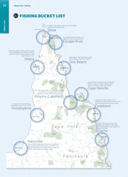
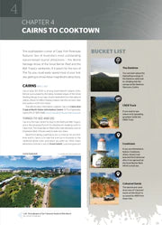
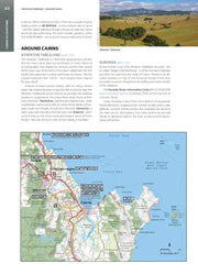
With detailed coverage of The Tip, the coast from Cairns to Cooktown, Rinyirru (Lakefield) National Park, the Peninsula Developmental Road, Old Telegraph Track, Torres Strait, and the Savannah Way, it ensures you won’t miss the ‘must-see’ attractions, but it also describes some of the lesser known areas favoured by the experts. Whether you just want to make it to The Tip or are looking for a serious 4WD adventure, this informative book is an indispensable companion.
The book features 15 4WD trips, explored and revised by travel journalist Ian Glover, with photography by Matt Williams. Each trip has a detailed map, plus all the information you need to plan the trip including trip grading, longest distance without fuel, permits, and contact details.
This brand new edition of Hema’s best-selling outdoor guidebook for discovering Cape York now features 22 atlas pages in a stunning new cartographic style and also incorporates content from the popular Cape York Travel & Adventure Guide by Ron and Viv Moon as well.
It was Dylan's staff pick!
Key features
- Featuring the top 15 4WD trips, including The Old Telegraph Track and Frenchmans Track
- Detailed inset maps for every track
- Best campsites
- Trip planning tips
- Contains a detailed Road Atlas for Cape York, including detailed mapping for The Tip
- Maps show fuel, camping areas, and rest areas
- New cartographic style with the latest mapping, points of interest, and facilities
- Mapping field-checked by the Hema Map Patrol.
Key Specifications
Edition: 5th, Publication Date: 01/09/17, Number of Pages: 208 (spiral bound), Height: 297mm, Width: 215mm, Depth: 15mm, Weight: 1.34kg
WHY WE LOVE HEMA MAPS...
Hema Maps is an Australian based mapping and publishing company that was founded in 1983. The company has expanded purposefully to the point where today it has comprehensive Australia and overseas map coverage in a variety of forms including folded maps, atlases, guides and digital products such as apps and dedicated GPS navigation systems.
With a keen focus on off-road touring, Hema Maps has steadily built its reputation as masterful map makers in the four-wheel driving and outdoor adventure industries. This reputation has come to the fore thanks to the company’s relentless pursuit of accurate cartographic detail relevant to outdoor explorers, realised by its unparalleled updating process.
The job of collecting and updating this data falls to field-teams known as the Map Patrol, who are responsible for exploring and mapping the vast array of off-road destinations in Australia to keep Hema Maps’ data accurate and up-to-date. Since 1996, Hema Maps has GPS mapped over 690,000km of tracks and 545,000km of unsealed roads throughout Australia, and will continue to pursue premium quality and accuracy within its product range into the foreseeable future.
You may also like
Sustain, Support & Explore
Eco-Friendly Packaging
Choose the Conron Store for eco-friendly packaging that's kind to the Earth.
Supporting Aussie Brands
We proudly support Aussie brands, nurturing local innovation and quality.
Embracing Outdoor Activities
Join us in spending 2 hours outside, 2 days a week, for a healthier lifestyle.